Research Project
Water Cycle Trends in the US Pacific Coast Using Satellite Data and Modeling
Research Team
Lead Researchers:
- Dr. Mario Giraldo, Ecological Analysis Using GIS, Geography
Collaborators:
- NASA
- Joe T. Roberts
- Jorge Vazquez
- Latha Baskaran
Student Team:
- Andrea Flores, BA Environmental Science
- Yashira Almanza, BS Computer Science
- Swany Cuc, BS Geography – GIS
Funding
- Funding Organization:
- Funding Program:
SYNOPSIS
- The purpose of this research is to gain insight into patterns/correlations
between environmental variabilities and ecological patterns. - Data Sources
- Freshwater Flux Data: Spanning from 1992-2018
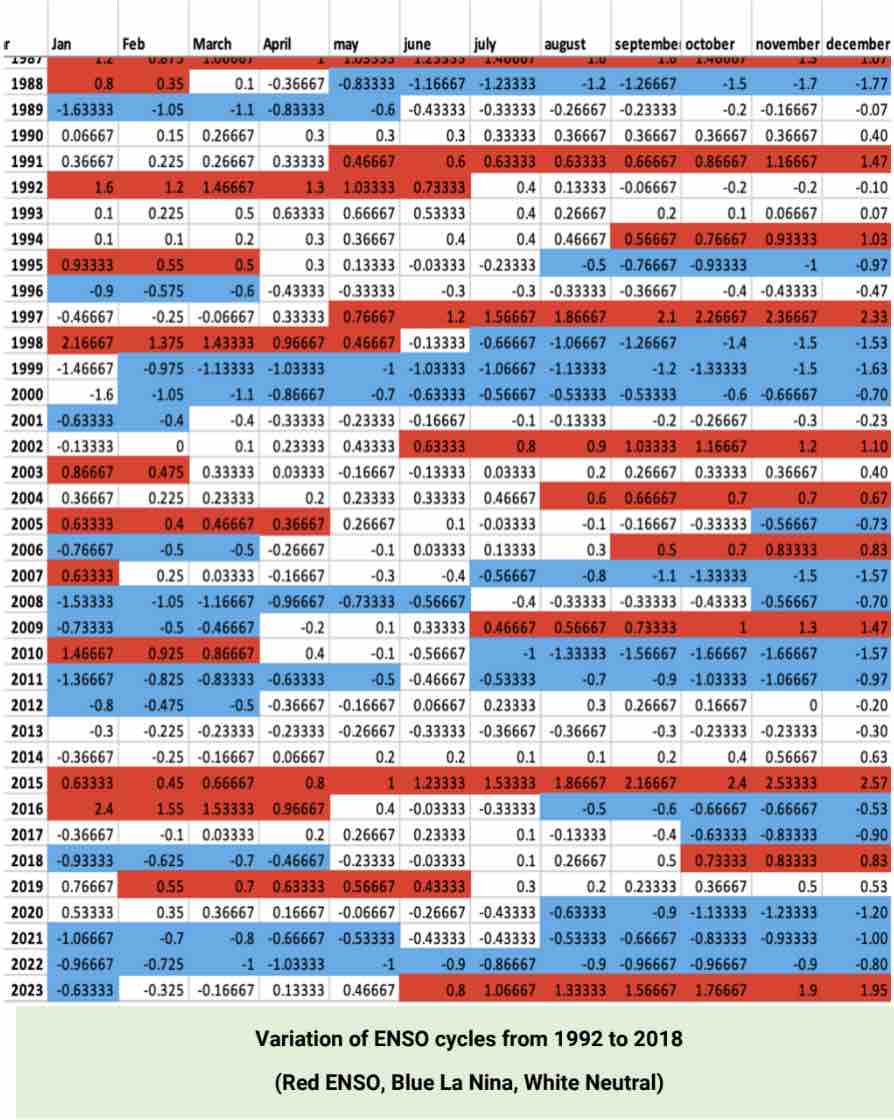
- Monthly El Niño-Southern Oscillation (ENSO) Data: Averaged data to
analyze climate variations
- Methodology
- Geographic Information Systems (GIS): Analyze spatial patterns and trends in freshwater flux.
- Excel: Integrate monthly averaged ENSO data


Research Questions & Research Objectives
-
Freshwater Flux is the movement and exchange of freshwater in Earth’s systems such as:
-
Atmosphere: precipitations and evaporation
-
Surface Water: rivers, lakes and oceans
-
Subsurface Water: ground water
-
-
ECCO (Estimating the Circulation and Climate of the Ocean) conceived the ocean as a major element of the global climate
-
Applications include climate trends and global warming, sea ice studies, regional estimates and studies of ocean variability, paleoclimate studies, and assimilate data for best fit model data
Research Methods
-
Assemble time series of weekly, monthly ECCO data for 20 years (1992 to 2018)
-
Segment the data according to ENSO, La Nina, and neutral cycles
-
Identify patterns for the USA Pacific Coast
-
Establish spatial correlations among variables in the ECCO dataset
-
Create animations and a story map to communicate trends to the larger public
Research Deliverables and Products
-
GIS Maps and Visualizations: Detailed maps showing spatial patterns of freshwater flux.
-
These visualizations illustrate temporal changes and correlations between datasets.
-
This is significant because it helps identify trends, predict future changes, and distinguish correlations with ENSO data. This resource helps visualize how freshwater fluxes vary over time and regions of focus.
Commercialization Opportunities
-
Education and Awareness
-
This research creates the opportunity to translate this complex data for the general public’s understanding.
-
Addressing this real-work challenge can create valuable services to mitigate the water cycle challenges in the Pacific Ocean.
-
Research Timeline
Start Date:
End Date:
Lead Researchers:
- Dr. Mario Giraldo, Ecological Analysis Using GIS, Geography
Collaborators:
- NASA
- Joe T. Roberts
- Jorge Vazquez
- Latha Baskaran
Student Team:
- Andrea Flores, BA Environmental Science
- Yashira Almanza, BS Computer Science
- Swany Cuc, BS Geography – GIS
Funding
- Funding Organization:
- Funding Program:
